The South Holston River in northeastern Tennessee is a premier destination for fly fishing enthusiasts, renowned for its abundant trout population and picturesque landscapes. To maximize your angling experience, utilizing a detailed fly fishing map of the South Holston River is indispensable.
Understanding The South Holston River
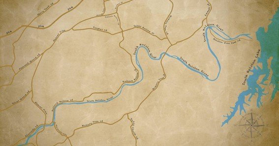
Stretching approximately 15 miles from the South Holston Dam to Boone Lake, the river maintains cold, oxygen-rich waters year-round, creating an ideal habitat for trout. This consistent environment supports a thriving population of brown and rainbow trout, with estimates of up to 8,500 fish per mile.
Key Access Points
A reliable fly fishing map highlights essential access points along the river:
- Weir Dam: Located just below the South Holston Dam, this area offers consistent water flows and is a hotspot for trout fishing.
- Emmett Bridge: Provides access to diverse water types, including riffles and pools, suitable for various fishing techniques.
- Big Springs Road: Offers multiple pull-off points for wading, granting anglers entry to productive fishing spots.
Float And Wade Fishing Sections
The river accommodates both float and wade fishing:
- Float Fishing: Sections like Emmett Bridge to the Spawning Ground are ideal for float fishing, featuring diverse water conditions and abundant trout populations.
- Wade Fishing: Areas near the Weir Dam and along Big Springs Road provide excellent wading opportunities, with accessible spots and thriving fish communities.
Utilizing A Fly Fishing Map
A comprehensive map not only indicates access points but also details:
- Parking Locations: Ensuring convenient and legal parking near fishing spots.
- Boat Ramps: Identifying launch sites for float fishing expeditions.
- Hatch Charts: Providing information on prevalent insect hatches to assist in fly selection.
- Recommended Flies: Suggesting effective fly patterns for specific river sections.
For instance, the South Holston River map by Fishwater Maps offers a waterproof, full-color guide encompassing these features, measuring 11″ x 17″ for easy handling.
Safety And Regulations
Before embarking on your fishing trip, consult the Tennessee Valley Authority (TVA) release schedule to stay informed about water flow conditions, as they can significantly impact fishing and safety. Additionally, adhere to local fishing regulations, including size and creel limits, to support conservation efforts.
FAQ
- Where can I obtain a detailed fly fishing map of the South Holston River?
Maps are available through local outfitters, online retailers, and specialized map publishers like Fishwater Maps. - What are the best times of year to fish the South Holston River?
The river offers year-round fishing opportunities, with peak activity during spring and fall due to favorable water temperatures and insect hatches. - Are there guided fishing services available on the South Holston River?
Yes, several local guide services offer trips tailored to various skill levels, providing equipment and expertise. - What types of trout are found in the South Holston River? The river is home to both brown and rainbow trout, with a significant population of wild brown trout.
- Is a fishing license required to fish the South Holston River?
Yes, a valid Tennessee fishing license is required for anglers aged 13 and above.
Equipping yourself with a detailed fly fishing map of the South Holston River enhances your angling experience by providing vital information on access points, fishing conditions, and effective strategies, ensuring a successful and enjoyable outing.